6.0 EQ Strikes Tonga – More Snow and Cold Wet Conditions On The Way

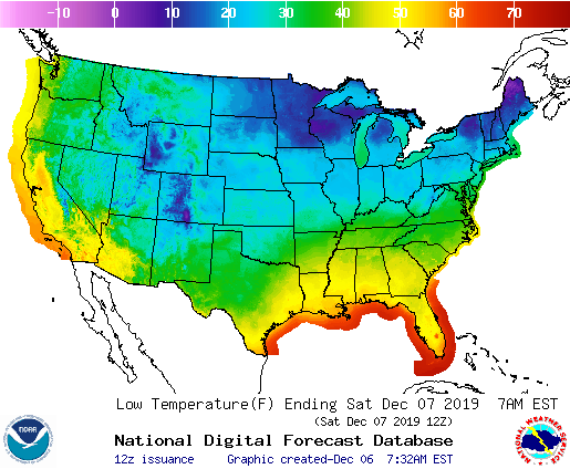
Snow expected for parts of the Lower Great Lakes/Northeast
Heavy snow for the highest elevations for Western Mountains… …
Rain for parts of Northern/Central California…
Fast moving low over the Lower Great Lakes will move eastward off the Northeast Coast by Friday evening. The system will produce snow over the Lower Great Lakes into parts of the Northeast on Friday ending overnight Friday. Additionally, upper-level energy over the Lower Mississippi Valley will move eastward off the Southeast Coast overnight Friday.
The system will produce rain over parts of the Lower Mississippi Valley that will move into the Southeast and slowly dissipate on Saturday morning.
Meanwhile, deep upper-level low over the Eastern Pacific will move into parts of the Pacific Northwest/Northern California while weakening by Saturday evening.
Moisture will stream into Northern California producing rain and highest elevation snow over parts of the Sierra Nevada Mountains into the Pacific Northwest by Saturday morning. On Saturday, the highest elevation snow and lower elevation rain will expand into parts of the Northern Intermountain Region and parts of the Great Basin.
Similarly, the snow and rain will move into parts of the Northern/Central Rockies overnight Saturday. Rain will also move into parts of the Southwest overnight Saturday, too.


A shallow earthquake registered by the USGS as M6.0 hit Tonga region at 13:04 UTC on December 6, 2019. The agency is reporting a depth of 10 km (6.2 miles). EMSC is reporting the same magnitude and depth.


UK forecast for the next 5 days
Milder and windier for most with heavy rain at times.
Today:
Windy with rain or showers at times during the day. Some bright or sunny spells spreading in from the northwest. Milder than recently for most of England and Wales but a colder day than Thursday over Scotland and Northern Ireland.
Tonight:
Showers clearing for most though some light rain continuing for high ground in the west. Frost free for most with easing winds. Colder for the Northern Isles with wintry showers.
Saturday:
Some bright or sunny spells in E Scotland and parts of England and Wales. Generally becoming cloudier and windier again with rain moving across Northern Ireland and into the north.
Outlook for Sunday to Tuesday:
Showery and cool Sunday, windy too with gales, locally severe around some coasts. Showers clear east on Monday; widespread frost Tuesday morning before further wet and very windy weather arrives.
TIME IS RUNNING OUT! SHIRTS START AT ONLY $16!

Facebook is classifying CO2 as a weapon…..
Here is the link to get the sticker since they wont let me post it.


JOIN US FOR OUR LIVE SHOWS:
MONDAY 8:30AM EST MORNING SHOW & 9PM EST EVENING SHOW
TUESDAY 8:30AM EST MORNING SHOW
WEDNESDAY 8:30AM EST MORNING SHOW & 9PM EST EVENING SHOW
THURSDAY 8:30AM EST MORNING SHOW
FRIDAY 8:30AM EST MORNING SHOW & 9PM EST EVENING SHOW
Please consider supporting our content at Patreon starting at 1 buck! https://www.patreon.com/grandsolarminimum
Help support what we do! https://www.gofundme.com/f/GSMNews
Subscribe Star https://www.subscribestar.com/grandsolarminimum
GSM Merch https://teespring.com/stores/grand-solar-minimum-gsm-merch


Patreon https://www.patreon.com/grandsolarminimum
Paypal https://www.paypal.me/TheGrandSolarMinimum
Find us on:
Minds https://www.minds.com/GRANDSOLARMINIMUM
Gab https://gab.com/GrandSolarMinimum
Facebook Group https://www.facebook.com/groups/GrandSolarMinimum/
Facebook Page https://www.facebook.com/thegrandsolarmini/
Twitter https://twitter.com/GrandSolarMin
Reddit https://www.reddit.com/user/GrandSolarMinimum
Bitchute https://www.bitchute.com/channel/thegrandsolarminimum/
Instagram https://www.instagram.com/grandsolarminimum