Montana hailstorm slaughters 11,000 birds
Winds of 70 mph whipped baseball-sized hail at a Montana lake. Thousands of birds fell victim.

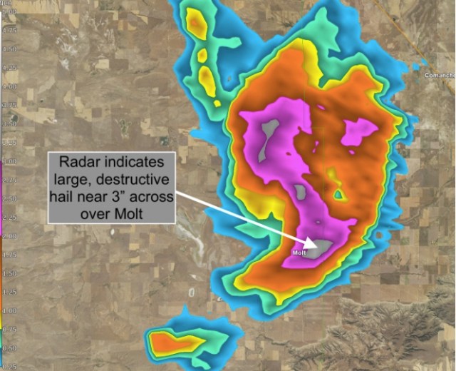
Thousands of birds were killed on Aug. 11 when a destructive hailstorm lashed regions northwest of Billings, Mont. According to Montana Fish, Wildlife and Parks, the supercell thunderstorm “killed and maimed more than 11,000 waterfowl and wetland birds at the Big Lake Wildlife Management Area west of Molt.” Molt is about 20 miles west-northwest of Billings, Montana’s largest city.
According to the news release, biologist Justin Paugh estimates that about a quarter of the birds at the lake were injured or killed. About 5 percent of surviving ducks and a third of living pelicans/cormorants “show some sign of injury or impaired movement.”
The Storm Prediction Center had already been calling for potential large, damaging hail as early as 12 hours in advance, outlining Billings in a narrow corridor of “significant severe” potential. Their morning bulletin advised that volatile atmospheric parameters would “favor supercells initially with large hail and possibly a couple of tornadoes.” By late afternoon, storms had developed, quickly becoming severe. Some storms towered nearly 10 miles high.

The National Weather Service issued a severe thunderstorm warning for Molt at 6:27 p.m., alerting of the potential for golf-ball-sized hail and damaging wind gusts in excess of 60 mph. The storm proved to be an overachiever, bringing an unusual August episode of three-inch hail and winds gusting up to 74 mph.
“This isn’t uncommon for us, but it normally happens in June,” explained Shawn Palmquist, a meteorologist at the National Weather Service in Billings. “June is when we have lower freezing levels and can get hail. August is typically more a wind month.”
“We only had a high of 82 degrees at Billings Airport last Sunday,” Palmquist said. “That was six degrees below normal, knocking freezing levels down just a bit. We also had above-average moisture.” That, coupled with strong wind dynamics, allowed thunderstorms to rotate — the secret ingredient necessary for spawning large hail.
Officially, the largest hail report at Big Lake Wildlife Management Area came in at 2.75 inches from a resident whose property abuts the Big Lake area. The homeowner reportedly lost four windows and a car windshield in the hailstorm, which featured pelting hail driven by strong thunderstorm winds.
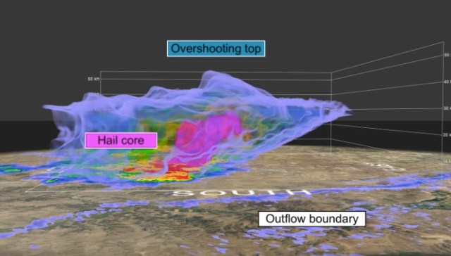
Doppler radar estimated hail size topping three inches near Molt. This 3-D volume rendering of the storm shows the hail core, highlighted in pink, stretching to 30,000 feet. That’s an extremely impressive core. An overshooting top can be seen above the hail core, the bubbling storm top indicative of an extremely strong updraft.
There are indications that, near the lake, large hail may have begun falling first, beating the rain by as much as five or six minutes. The birds probably had no warning.

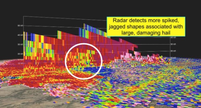
Another feature of the storm was that the hail was spiked and jagged. Correlation coefficient radar shows an area of reduced returns where more irregular shapes are detected within the storm. This is possibly the pocket of hail that decimated the birds. A concentrated layer of chaotic shapes, whether biological or meteorological, can be seen in a narrow strip near the surface. –Matthew Cappucci

While three quarters of Big Lake’s bird population survived, biologists are concerned that brewing disease could threaten the birds that remain.
Nearby Billings, a city of 100,000, saw hail of 2 inches in diameter.
Wind-driven hail damage to a home in Ballantine, Montana, from a severe storm Sunday evening. (Larry Mayer/The Billings Gazette via AP) pic.twitter.com/E4y7wMIVsU
— Chris Dolce (@chrisdolcewx) August 13, 2019
